 EMODnet Product Catalogue
Fundaci├│n Biodiversidad (Biodiversity Fundation)
Type of resources
Available actions
Topics
Keywords
Contact for the resource
Provided by
Years
Formats
Representation types
Update frequencies
status
Scale 1:
-
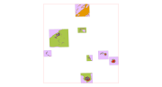
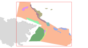
This dataset contains the habitats map from the SCI (Site of Community Importance) ÔÇ£Espacio marino de Illes ColumbretesÔÇØ. The Columbretes Islands, a series of small islands, islets and submerged elevations of volcanic origin, are found in the Western Mediterranean at the northern limit of the Gulf of Valencia, 28 miles from the Gulf of Oropesa and just over 50 kilometers from the coast to the east of Castell├│n de la Plana. There are 24 islets gathered in 4 groups each named after its largest landmass. This volcanic field covers an area of 90 by 40 kilometers at a depth of 80 to 90 metres. The Illa Grossa and the other islands and islets are formed from basaltic materials or phonolitic rocks. These islands and the associated submerged volcanic field are one of the rare examples of Quaternary volcanism in the Mediterranean. This study was supported by the INDEMARES-LIFE+ Project, EC contract INDEMARES-LIFE+ (07/NAT/E/000732): Inventory and Designation of the Natura 2000 network in marine areas of the Spanish State (www.indemares.es/en). This work was coordinated by the Biodiversity Foundation (www.fundacion-biodiversidad.es). This study was made possible through the collaboration of multiple teams of researchers: Department of Ecology (University of Barcelona - UB), Center for Advanced Studies of Blanes (CEAB - CSIC), Institute of Marine Sciences (ICM - CSIC), Balearic Oceanography Centre (COB) - IEO (Spanish Institute of Oceanography) and Consolidate Research Group Marine Geosciences (GRC-GM) (University of Barcelona - UB). Habitats are classified according to EUNIS nomenclature and the List of Marine Habitats in Spain (LPRE, that itÔÇÖs classified hierarchically and was completed and published in March 2013). Habitats classification are been simplified owing to the requirements of the EMODnet (European Marine Observation and Data Network) portal for Seabed Habitats.
-
This dataset contains the main habitats maps from the SCI (Site of Community Importance) ÔÇ£Banco de GaliciaÔÇØ. The Galician Bank is a deep underwater mountain located at the northwest of the Iberian Peninsula, 180 km from the Galician coast (in the north-east Atlantic Ocean). Its summit is located at a depth of between 650 and 1,500 metres. Its steep slopes descend from the summit to the abyssal plains located 4,000 meters below sea level. This study was supported by the INDEMARES-LIFE+ Project, EC contract INDEMARES-LIFE+ (07/NAT/E/000732): Inventory and Designation of the Natura 2000 network in marine areas of the Spanish State (www.indemares.es/en). This work was coordinated by the Spanish Institute of Oceanography (IEO, www.ieo.es) and the Biodiversity Foundation (www.fundacion-biodiversidad.es). The interpretation has been made possible thanks to direct and indirect samplings and geophysical data from campaigns "ECOMARG09", "INDEMARES_BANGAL0810", "INDEMARES_BANGAL0711" and "RADPROF0912". Habitats are classified according to EUNIS nomenclature and the List of Marine Habitats in Spain (LPRE, that itÔÇÖs classified hierarchically and was completed and published in March 2013).
-
This dataset contains the main habitats maps from the SCI (Site of Community Importance) ÔÇ£Sur de Almer├¡a - Seco de los OlivosÔÇØ. Seco de los Olivos is a seamount situated in the Alboran Sea (western Mediterranean, southeast Iberian peninsula). This study was supported by the INDEMARES-LIFE+ Project, EC contract INDEMARES-LIFE+ (07/NAT/E/000732): Inventory and Designation of Marine Natura 2000 Network areas in the Spanish seas (www.indemares.es/en). This work was coordinated by the Spanish Institute of Oceanography (IEO, www.ieo.es) and the Biodiversity Foundation (www.fundacion-biodiversidad.es). The interpretation has been made possible thanks to direct and indirect samplings and geophysical data from campaigns ÔÇ£OCEANA I-2010ÔÇØ, ÔÇ£OCEANA II-2011ÔÇØ, ÔÇ£OCEANA III-2012ÔÇØ and ÔÇ£INDEMARES_SECO1012ÔÇØ. Habitats are classified according to EUNIS nomenclature and the List of Marine Habitats in Spain (LPRE, that itÔÇÖs classified hierarchically and was completed and published in March 2013).
-
This dataset contains the habitats map from the SCI (Site of Community Importance) ÔÇ£Canal de MenorcaÔÇØ. The "Menorca Channel" is a marine corridor located between the islands of Mallorca and Menorca in the Balearic Islands archipelago, with a minimum distance between the two islands of 36 kilometers. Its geographical position in the centre of the Western Mediterranean and its location, between islands, gives the area a peculiar set of oceanographic characteristics, including strong currentsand unusually transparent waters. This study was supported by the INDEMARES-LIFE+ Project, EC contract INDEMARES-LIFE+ (07/NAT/E/000732): Inventory and Designation of the Natura 2000 network in marine areas of the Spanish State (www.indemares.es/en). This work was coordinated by the Biodiversity Foundation (www.fundacion-biodiversidad.es). Habitats are classified according to EUNIS nomenclature and the List of Marine Habitats in Spain (LPRE, that itÔÇÖs classified hierarchically and was completed and published in March 2013). Habitats classification are been simplified owing to the requirements of the EMODnet (European Marine Observation and Data Network ) portal for Seabed Habitats.
-
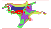
This dataset contains the habitats map from the SCI (Site of Community Importance) ÔÇ£Sistema de Ca├▒ones Submarinos Occidentales del Golfo de Le├│nÔÇØ. The marine area ÔÇ£South-West Gulf of Lions canyons systemÔÇØ is located in the northeastern part of the Iberian Peninsula. The coastline belongs to the Catalan province of Girona, featuring a large number of rocky outcrops with many coves, small beaches, vertical cliffs and islets. Cape Creus is the most notorious element of the landscape, which corresponds to the easternmost part of the Pyrenees Mountains. This small peninsula is characterized by its wildness, and despite its low relief it penetrates into the Mediterranean Sea for more than 10 kilometers.This study was supported by the INDEMARES-LIFE+ Project, EC contract INDEMARES-LIFE+ (07/NAT/E/000732): Inventory and Designation of the Natura 2000 network in marine areas of the Spanish State (www.indemares.es/en). This work was coordinated by the Biodiversity Foundation (www.fundacion-biodiversidad.es). Habitats are classified according to EUNIS nomenclature and the List of Marine Habitats in Spain (LPRE, that itÔÇÖs classified hierarchically and was completed and published in March 2013). Habitats classification are been simplified owing to the requirements of the EMODnet (European Marine Observation and Data Network) portal for Seabed Habitats.
-
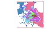
This dataset contains the habitats map from the SCI (Site of Community Importance) ÔÇ£Sistema de ca├▒ones submarinos de Avil├®sÔÇØ (Avil├®s Canyon System). The Avil├®s Canyon system is located in the eastern sector of the North Atlantic Ocean, on the continental margin to the north of the Iberian Peninsula. It is structurally a highly complex area, where the continental shelf in the Bay of Biscay is deeply affected by the action of tectonic compression, containing important geomorphological elements; these include: three great submarine canyons, a marginal platform and a tall structural rocky mass. This study was supported by the INDEMARES-LIFE+ Project, EC contract INDEMARES-LIFE+ (07/NAT/E/000732): Inventory and Designation of the Natura 2000 network in marine areas of the Spanish State (www.indemares.es/en). This work was coordinated by the Spanish Institute of Oceanography (IEO, www.ieo.es) and the Biodiversity Foundation (www.fundacion-biodiversidad.es). The interpretation has been made possible thanks to direct and indirect samplings and geophysical data from campaigns INDEMARES (AVILES_0710, AVILES_0410, AVILES_0412-0912). Habitats are classified according to EUNIS nomenclature and the List of Marine Habitats in Spain (LPRE, that itÔÇÖs classified hierarchically and was completed and published in March 2013).
-
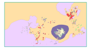
This dataset contains the habitats map from the SCI (Site of Community Importance) ÔÇ£Volcanes de fango del Golfo de C├ídizÔÇØ. The Gulf of Cadiz is located in the eastern sector of the North Atlantic Ocean, to the southwest of the Iberian Peninsula. Mud Volcanoes are seafloor edifices, of a usually conical geometry, that result from the release of mud, hydrocarbon and fluids in gas-rich areas over pressured sediments. This study was supported by the INDEMARES-LIFE+ Project, EC contract INDEMARES-LIFE+ (07/NAT/E/000732): Inventory and Designation of the Natura 2000 network in marine areas of the Spanish State (www.indemares.es/en). This work was coordinated by the Spanish Institute of Oceanography (IEO, www.ieo.es) and the Biodiversity Foundation (www.fundacion-biodiversidad.es). The interpretation has been made possible thanks to direct and indirect samplings and geophysical data from campaigns INDEMARES_CHICA (CHICA0610, CHICA0211, CHICA1011 and CHICA0412). Habitats are classified according to EUNIS nomenclature and the List of Marine Habitats in Spain (LPRE, that itÔÇÖs classified hierarchically and was completed and published in March 2013).